Understanding, tracking, and predicting nutrient loads from the Western Lake Erie Basin (WLEB) watershed is challenging due to the complex drivers of nutrient loss within sub-watersheds in the WLEB, including variable weather, cropping systems, farm management, and nutrient cycling.
In 2025, Freeboard Technology partnered with the Alliance for the Great Lakes and Michigan State University to build and deploy water quality monitoring infrastructure at 50 locations throughout the River Raisin watershed and direct tributaries to the WLEB. This higher spatial density monitoring instrumentation will enable the Michigan Department of Rural Development (MDARD), partners, and practitioners to implement better conservation and land management practices to meet phosphorus reduction goals.
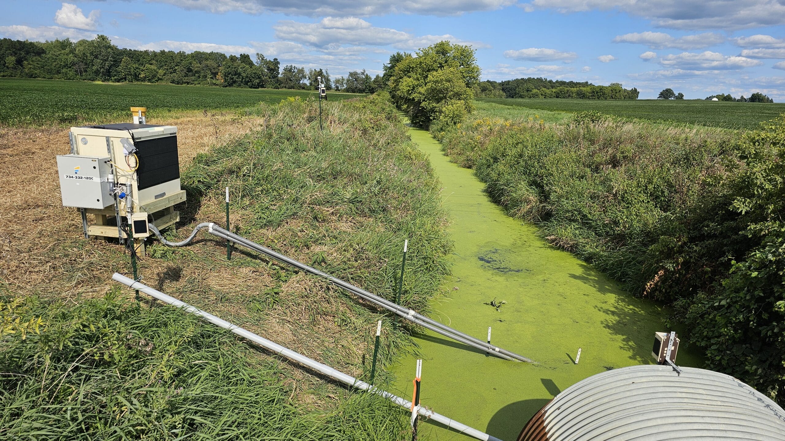
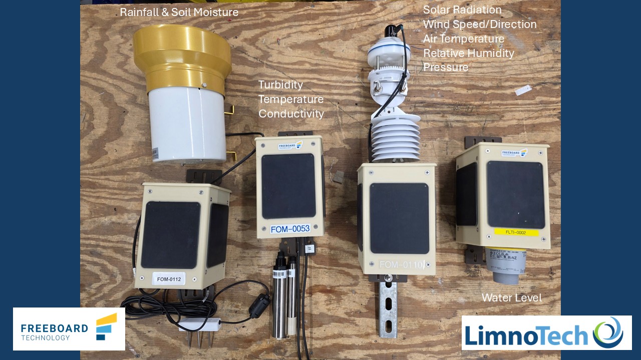
Freeboard Technology developed and built the monitoring equipment, which includes weather stations, water quality monitoring sensors, water level sensors, automated grab samplers, and online real-time phosphorus analyzers. All the equipment is solar-powered and transmits data near-real time through cellular, enabling real-time insights that can inform manual grab sampling.
Below is a summary of the monitoring equipment deployed to date.
Water Quality – 50 Water Quality stations were deployed throughout the River Raisin watershed. These sensors measure water temperature, conductivity, and turbidity. Measurements are taken every 15 minutes.
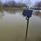
Water Level – 50 Water Level stations were deployed throughout the River Raisin watershed. These stations provide an extremely accurate water level measurement using a radar-based sensor. Since the stations are solar-powered and non-contact, they can stay out year-round and provide valuable water level data.
Weather – 9 weather stations were deployed throughout the River Raisin watershed. These stations measure wind speed, wind gust, air temperature, solar radiation, pressure, barometric pressure, dew point, relative humidity, precipitation, soil temperature, and soil moisture. This weather station network allows for a higher-resolution collection of data from storm events.
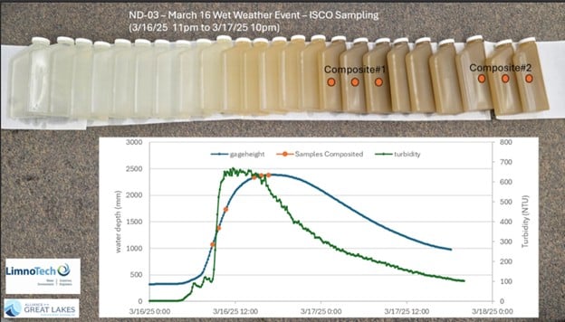
Automated Grab Samples and Nutrients – 9 automated grab samplers and online nutrient analyzers were deployed through the River Raisin watershed. These stations feature an automated water collection system that can be controlled remotely. This allows the sampling protocol to be initiated, adjusted and terminated remotely. The samples are stored in a refrigerated container. Additionally, an online near-real-time nutrient analyzer is onboard measuring soluble reactive phosphorus (SRP). The nutrient analyzer takes an SRP measurement every four hours and can be deployed for six weeks at a time before needed to replenish the reagents.
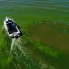
The sensor network has captured several spring storm events, which are thought to be the primary driver of harmful algal blooms (HABs) in the WLEB. Data from the storm events will provide crucial information on how nutrients and sediment flush through the watershed during intense rainfall. The ability to trigger sampling remotely has enabled field staff to capture storm events with minimal preparation.
The WLEB watershed project is funded by the MDARD and the Erb Family Foundation. Monitoring will continue through 2029. Updates can be found on the project website: Expanded Water Quality Monitoring in the Western Lake Erie Watershed – Alliance for the Great Lakes.
Here are other locations this project has been featured:
Answering the Challenge of Harmful Algal Blooms in the Western Lake Erie Basin
MI and OH: Different strategies to reduce Lake Erie nutrient pollution
Monitoring Milestone in Fight Against Lake Erie Pollution
WLEB 2025 Winter Webinar Series: High Density Water Quality Monitoring